Migrating animals add new depth to how the ocean “breathes” (Nature Geoscience)

By Morgan Kelly, Office of Communications

The oxygen content of the ocean may be subject to frequent ups and downs in a very literal sense — that is, in the form of the numerous sea creatures that dine near the surface at night then submerge into the safety of deeper, darker waters at daybreak.

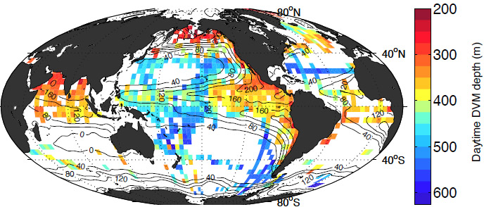
Research begun at Princeton University and recently reported on in the journal Nature Geoscience found that animals ranging from plankton to small fish consume vast amounts of what little oxygen is available in the ocean’s aptly named “oxygen minimum zone” daily. The sheer number of organisms that seek refuge in water roughly 200- to 650-meters deep (650 to 2,000 feet) every day result in the global consumption of between 10 and 40 percent of the oxygen available at these depths.

The findings reveal a crucial and underappreciated role that animals have in ocean chemistry on a global scale, explained first author Daniele Bianchi, a postdoctoral researcher at McGill University who began the project as a doctoral student of atmospheric and oceanic sciences at Princeton.

Migration depth of sea animals
Research begun at Princeton University found that the numerous small sea animals that migrate from the surface to deeper water every day consume vast amounts of what little oxygen is available in the ocean’s aptly named “oxygen minimum zone” daily. The findings reveal a crucial and underappreciated role that animals have in ocean chemistry on a global scale. The figure above shows the various depths (in meters) that animals migrate to during the day to escape predators. Red indicates the shallowest depths of 200 meters (650 feet), and blue represents the deepest of 600 meters (2,000 feet). The black numbers on the map represent the difference (in moles, used to measure chemical content) between the oxygen at the surface and at around 500 meters deep, which is the best parameter for predicting migration depth. (Courtesy of Daniele Bianchi)

“In a sense, this research should change how we think of the ocean’s metabolism,” Bianchi said. “Scientists know that there is this massive migration, but no one has really tried to estimate how it impacts the chemistry of the ocean.

“Generally, scientists have thought that microbes and bacteria primarily consume oxygen in the deeper ocean,” Bianchi said. “What we’re saying here is that animals that migrate during the day are a big source of oxygen depletion. We provide the first global data set to say that.”

Much of the deep ocean can replenish (often just barely) the oxygen consumed during these mass migrations, which are known as diel vertical migrations (DVMs).

But the balance between DVMs and the limited deep-water oxygen supply could be easily upset, Bianchi said — particularly by climate change, which is predicted to further decrease levels of oxygen in the ocean. That could mean these animals would not be able to descend as deep, putting them at the mercy of predators and inflicting their oxygen-sucking ways on a new ocean zone.

“If the ocean oxygen changes, then the depth of these migrations also will change. We can expect potential changes in the interactions between larger guys and little guys,” Bianchi said. “What complicates this story is that if these animals are responsible for a chunk of oxygen depletion in general, then a change in their habits might have a feedback in terms of oxygen levels in other parts of the deeper ocean.”

The researchers produced a global model of DVM depths and oxygen depletion by mining acoustic oceanic data collected by 389 American and British research cruises between 1990 and 2011. Using the background readings caused by the sound of animals as they ascended and descended, the researchers identified more than 4,000 DVM events.

They then chemically analyzed samples from DVM-event locations to create a model that could correlate DVM depth with oxygen depletion. With that data, the researchers concluded that DVMs indeed intensify the oxygen deficit within oxygen minimum zones.

“You can say that the whole ecosystem does this migration — chances are that if it swims, it does this kind of migration,” Bianchi said. “Before, scientists tended to ignore this big chunk of the ecosystem when thinking of ocean chemistry. We are saying that they are quite important and can’t be ignored.”

Bianchi conducted the data analysis and model development at McGill with assistant professor of earth and planetary sciences Eric Galbraith and McGill doctoral student David Carozza. Initial research of the acoustic data and development of the migration model was conducted at Princeton with K. Allison Smith (published as K.A.S. Mislan), a postdoctoral research associate in the Program in Atmospheric and Oceanic Sciences, and Charles Stock, a researcher with the Geophysical Fluid Dynamics Laboratory operated by the National Oceanic and Atmospheric Administration.

Read the abstract

Citation: Bianchi, Daniele, Eric D. Galbraith, David A. Carozza, K.A.S. Milan and Charles A. Stock. 2013. Intensification of open-oxygen minimum zones by vertically migrating animals. Nature Geoscience. Article first published online: June 9, 2013. DOI:10.1038/ngeo1837

This work was supported in part by grants from the Canadian Institute for Advanced Research and the Princeton Carbon Mitigation Initiative.


Pebbles and sand on Mars best evidence that a river ran through it (Science)

NASA Pebbles on Mars
Pebble-rich rock slabs have been observed on Mars, suggesting the presence of an ancient stream bed (Source: Science)

By Morgan Kelly, Office of Communications

Pebbles and sand scattered near an ancient Martian river network may present the most convincing evidence yet that the frigid deserts of the Red Planet were once a habitable environment traversed by flowing water.

Scientists with NASA’s Mars Science Laboratory mission reported May 30 in the journal Science the discovery of sand grains and small stones that bear the telltale roundness of river stones and are too heavy to have been moved by wind. The researchers estimated that the sediment was produced by water that moved at a speed between that of a small stream and a large river, and had a depth of roughly an inch to nearly 3 feet.

Co-author Kevin Lewis, a Princeton associate research scholar in geosciences and a participating scientist on the Mars mission, said that the rocks and sand are among the best evidence so far that water once flowed on Mars, and suggest that the planet’s past climate was wildly different from what it is today.

“This is one of the best pieces of evidence we’ve seen on the ground for flowing water,” Lewis said. “The shape of these rocks and sand is exactly the same kind of thing you’d see if you went out to any streambed. It suggests a very similar environment to the Earth’s.”

The researchers analyzed sediment taken from a Martian plain that abuts a sedimentary deposit known as an alluvial fan. Alluvial fans are comprised of sediment leftover when a river spreads out over a plain then dries up, and are common on Earth in arid regions such as Death Valley.

Yet Death Valley is a refreshing spring compared to Mars today, Lewis said. Satellite images taken in preparation for the 2012 landing of NASA’s Curiosity Mars rover had revealed ancient river channels carved into the land on and around Mount Sharp, a 3.5-mile high mound similar in size to Alaska’s Mt. McKinley that would become the rover’s landing site. A major objective of the Curiosity mission is to explore Mars’ past habitability.

Nonetheless, liquid water itself is most likely rare on Mars’ currently cold and dusty landscape where wind is the dominant force. Lewis was co-author on a paper in the May 2013 edition of the journal Geology that suggested that Mount Sharp, thought to be the remnant of a massive lake, is most likely a giant dust pile produced by Mars’ violent, swirling winds.

Strong as it might be, however, wind cannot move sediment grains with a diameter larger than a few millimeters, Lewis said. The sand and stones he and his colleagues analyzed had diameters ranging from one to 40 millimeters, or roughly the size of a mustard seed to being only slightly smaller than a golf ball. The roundness of the sediment also suggested a prolonged eroding force, Lewis said.

“Once you get above a couple of millimeters the wind will not be able to mobilize sediment. A number of the grains we see in this outcrop are substantially bigger than that,” Lewis said. “That really leaves us with fluvial transport as the most likely process. We knew Curiosity was landing near the fan, but to land right on top of these rocks that suggest the presence of water was really fortuitous.”

If the sediment does mean a river ran through Mars, the researchers must next determine when, where it came from and how it dried up, a project that will be a “major scientific project over the coming year,” Lewis said. The mystery also centers on the potential relationship of the river to the scars on Mount Sharp: Did the river flow down it? Was the mound a source of water after all?

“This evidence tells us that there were a diverse set of geological processes happening at roughly the same time within the proximity of [the landing site], and it gives us a picture of a much more dynamic Mars than we see today,” Lewis said. “Finding out how exactly they relate will be an exciting story.”

Read the abstract.

Citation: Williams, R.M.E., et al. 2013. Martian fluvial conglomerates at Gale Crater. Science. Article first published online: May. 30, 2013. DOI: 10.1126/science.1237317

This work was supported in part by grants from NASA Mars Program Office.