Krithin Sitaram (krithin@) – Krithin conversed with people in contextual interviews, and wrote about contextual interviews descriptions and task descriptions.
Amy Zhou (amyzhou@) – Amy drew a storyboard, conversed with people in contextual interviews, and wrote about user descriptions and task descriptions.
Daniel Chyan (dchyan@) – Daniel drew a storyboard, wrote about the interface design, observed interviewees during contextual interviews, and wrote about task descriptions.
Jonathan Neilan (jneilan@) – Jonathan took notes during contextual interviews, and took pictures of the design sketches.
Thomas Truongchau (ttruongc@) – Thomas drew a storyboard, wrote about task descriptions, and took pictures of all the storyboards.
Essentially, each person addressed different problems when they arose.
Problem and solution overview
Smartphone map apps are useful but very demanding of the user’s visual attention, and still require the user to be able to read a map. Our proposed solution is to outfit a belt that the user will wear with a number of buzzers; this will interact with a user’s smartphone to determine the user’s location and bearing and vibrate the appropriate motor to indicate the direction the user should walk.
Description of users you observed in the contextual inquiry
Our first target user group includes travelers in an unfamiliar area who want to travel hands-free. Our rationale behind choosing this user group is because they tend to have their hands full and need a solution that will help them quickly move from place to place without referring to a map or phone.
Our second target user group includes people searching in Firestone library. Actual tourists are hard to find this time of year, so we chose students attempting to locate things in Firestone as an approximation. They have the problem of making their way around an unfamiliar environment. This allowed us to gather insight into how they use the same tools that people use when navigating a larger scale unfamiliar environment, like a city.
Persons observed in contextual interviews
At the transit center:
1. Two female adults, probably in their mid-20s, who were very outgoing and excited about traveling. They were primarily occupied with getting where they were going, but also wanted to have fun along the way! They were good target users because they were new to the area, having just arrived from the airport, and also had a distinct destination they wanted to get to; they also did not want to expose electronics to the rain, so they fit in the category of travelers who would have liked to have hands-free navigation.
2. Two women, probably in their early 20s, weighed down by shopping bags and a small child. They were fairly familiar with transit in general, but not with this particular transit center. Their top priority was not getting lost. They were good observation candidates because they were in a hurry but were having trouble using existing tools — they were uncertain whether they were on the right bus, and waited for several minutes at the wrong bus stop.
At Firestone:
1. Female student searching for a book in the B level, then looking for the way back to her desk. She does not know Firestone well, and was using a map of the library on her laptop to get around.
2. Male student searching for his friend in the C level of Firestone. He knew the general layout of that part of the library, but did not know precisely where his friend would be. It seemed time was less of a priority for him than convenience, because he was content wandering around a relatively large area instead of texting his friend to get a more precise location (e.g. call number range of an adjacent stack) and using a map to figure out directions to that location.
3. The official bookfinder on the B-level of Firestone provided some information about the way people came to her when they needed help finding a book. Although she was not part of our user group herself (since she was trained in finding her way around the library) she was a useful source because she could draw on her experience on the job and tell us about the behaviors of many more people than we could practically interview.
CI Interview Descriptions
We carried out interviews in two different settings. Firstly, we observed people attempting to find their way around using public transit who were waiting at the Santa Clara Transit Center, while it was dark and raining, immediately after a bus had arrived from the airport, thus carrying many people who had just arrived in the area. Secondly, we observed people in Firestone library as they attempted to find books or meet people at specific locations in the library. In addition to direct observations, we also interviewed a student employed as a ‘bookfinder’ in the library to get a better sense of the users we expected would need help finding their way around. We approached people who were walking near the book stacks or disgorged from the elevator; asked them what they were looking for, and followed them to their destination. One person recorded observations by hand while another talked to the participant to elicit explanations of their search process.
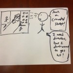
One common problem people faced was that even with a map of the location they were uncertain about their exact position, and even more so about their orientation. This is understandable because it’s very easy to get turned around, especially when they are constantly looking from side to side. Recognizable landmarks can help people identify where they are on a map, but it is harder to figure out their orientation from that. Another problem is that people are often overconfident in their ability to navigate a new area. For instance, at the transit center, one informant was sitting at a bus stop for quite some time, apparently very confident that this was the correct bus stop, only to run across the parking lot several minutes later and breathlessly exclaim “We were waiting at the wrong bus stop too!” The first student we interviewed in Firestone also told us that she knew the way back to her desk well (even though she admitted to being “bad with directions”), but nevertheless had to keep looking around as she passed each row in order to find it.
One Firestone interviewee revealed another potential problem; he was looking for a friend in the library but only knew which floor and which quadrant of the library his friend was in, and planned to wander around till the friend was found. This indicates that another task here is the mapping between the user’s actual goals and a physical location on the map; we expect however that this should be easier for most users of our system, since for example the transit passengers and the students in search of books in the library had very precise physical locations they needed to go to. Even when users are following a list of directions, the map itself sometimes has insufficient resolution to guide the user. For instance, at the transit center, all the bus stops were collectively labeled as a single location by Google Maps, with no information given as to the precise locations of the bus stops within that transit center.
Answers to 11 Task Analysis Questions
1. Who is going to use system?
Specific target group:
People who are exploring a new location and don’t want to look like a tourist.
2. What tasks do they now perform?
Identify a physical destination (e.g. particular location in library) that they need to go to to accomplish their goal (e.g. get a certain book).
Harder to define for some goals (‘looking for a friend in the library’)
Determine their own present location and orientation
E.g. Transit passengers try using GPS; inside library people look at maps and landmarks.
Identify a route from their location to their destination, and move along it.
As they proceed along the route, check that they have not deviated from it.
e.g. the transit passengers
3. What tasks are desired?
Identify a physical destination that they need to get to.
Receive information about next leg of route
Reassure themselves that they are on the the right path
4. How are the tasks learned?
Users download a maps application or already have one and figure it out. They usually do not need to consult a manual or other people.
Boy Scouts orienteering merit badge
Trial and error #strug bus
Watching fellow travelers
5. Where are the tasks performed?
Choosing a destination can happen at the user’s home, or wherever is convenient, but the remainder of the tasks will happen while travelling along the designated route.
6. What’s the relationship between user & data?
Because each person has a unique path, data will need to cater to the user. Privacy concerns are limited, because other people will necessarily be able to see the next few steps of the path you take if they are physically in the same location. However, broadcasting the user’s complete itinerary would be undesirable.
7. What other tools does the user have?
Google maps
Other travelers, information desks, bus drivers, locals…
Physical maps
Signs
Compasses
8. How do users communicate with each other?
Verbally
Occasionally, text messaging
9. How often are the tasks performed?
When the user is in an unfamiliar city, which may happen as often as once every few weeks or as rarely as on the order of years, depending on the user, the user will need to get directions several times a day.
10. What are the time constraints on the tasks?
Users sometimes have only a few minutes to get to a location in order to catch a bus, train, or plane, or have to get to their destination within a few minutes.
11. What happens when things go wrong?
In the case of system failure, users will be able to use preexisting tools and ask other people for directions.
Description of Three Tasks
1. Identify a physical destination that they need to get to.
Currently, this task is relatively easy to perform. On the web, existing tools include applications like Google Maps or Bing Maps. Users generally input a target destination and rely on the calculated path in order to get directions. However, the task becomes moderately difficult when consulting directions on the go. Users inconvenience themselves when they need to take out their phone, refer to the map and directions, and then readjust their route accordingly.
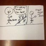
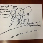
Our proposed system would make the task easier and less annoying for users who are physically walking. After the user identifies a physical destination, the navigation belt will help guide the user towards the target. Our system eliminates the inconvenience of constantly referring to a map by giving users tactile directional directions. This is discrete and inconspicuous.
2. Receive information about immediate next steps
Determine in what direction the user should be walking. This can be moderately difficult using current systems, because orientation is sometimes difficult to establish at the start of the route, and the distance to the next turn is usually not intuitive. For example, users of current mapping systems may have to walk in a circle in order to figure out a frame of reference to determine the correct direction because a user must orient the mobile phone. With our proposed system, the direction will be immediately obvious, because the orientation of the belt remains stable. Our proposed system will make this task relatively easier.
3. Reassure themselves that they are on the the right path
The user often wants to know whether they are still on the right track, or whether they missed a turn several blocks ago. The user attempts this task once in a while if they are confident, but if they are in a confusing area they might want this information very often or even continuously. Currently, checking whether the user is still on the right path is not very difficult but rather annoying, since it requires pulling out a map or phone every few minutes to gain very little information. With our proposed system, it would be extremely simple, because as long as the front panel is vibrating, the user knows that he or she is walking in the right direction.
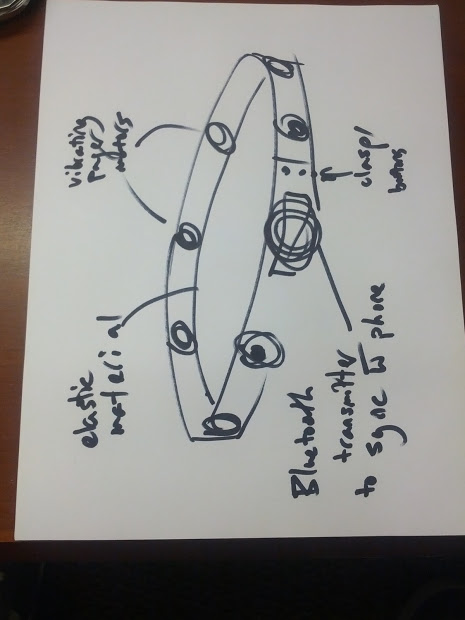
Interface Design
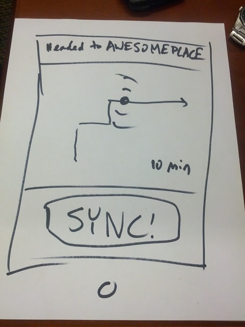
The system provides users with the ability to orient themselves in a new environment and receive discreet directions through tactile feedback. A user can ask for directions and the system will vibrate in one of 8 directions to guide the user through a series of points towards a destination. Benefits of the system include discrete usage and providing an additional sense of direction beyond the current maps provided by Google and Microsoft. Reliance on a tactile system also reduces the demand on visual attention which allows users to focus more on his or her surroundings. The scope of functions will encompass orienting towards points of interest and providing directions to those points. No longer will users need to stare at a screen to find their way in unfamiliar locations or spin in a circle to find the correct orientation of directions.
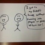
Storyboard 1:
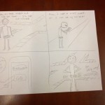
Storyboard 2:
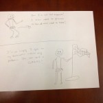
Storyboard 3:
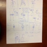
Design of NavBelt
Design of Mobile Application Interface