Reshaping mountains in the human mind to save species facing climate change (Nature Climate Change)

2015_05_18_Himalaya_ElsenBy Morgan Kelly, Office of Communications

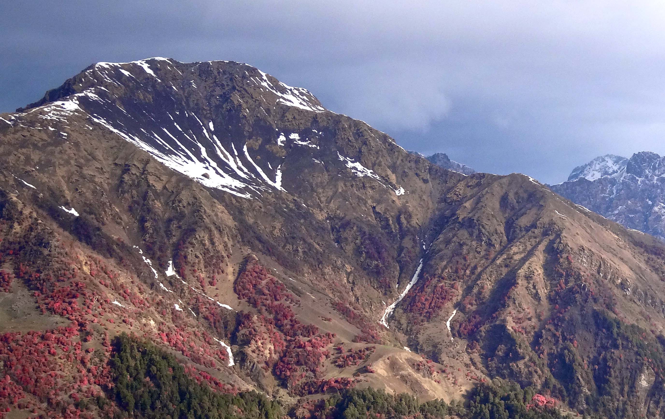
People commonly perceive mountain ranges as jumbles of pyramid-shaped masses that steadily narrow as they slope upward.

While that’s certainly how they appear from a ground-level human viewpoint, a new study shows that pyramid-shaped mountains are not only a minority in nature, but also that most ranges actually increase in area at higher elevations. Besides reshaping the mountains in our mind’s eye, the findings could lead scientists to reconsider conservation strategies — which are often based on misconceptions about mountain terrain — for mountain animal species threatened by climate change.

Researchers at Princeton University and the University of Connecticut conducted the first study to map the shape of the world’s major mountain ranges and found that the classic triangular form in which land-area uniformly decreases as elevation increases only applies to roughly one-third of the world’s mountain ranges, according to a report in the journal Nature Climate Change.

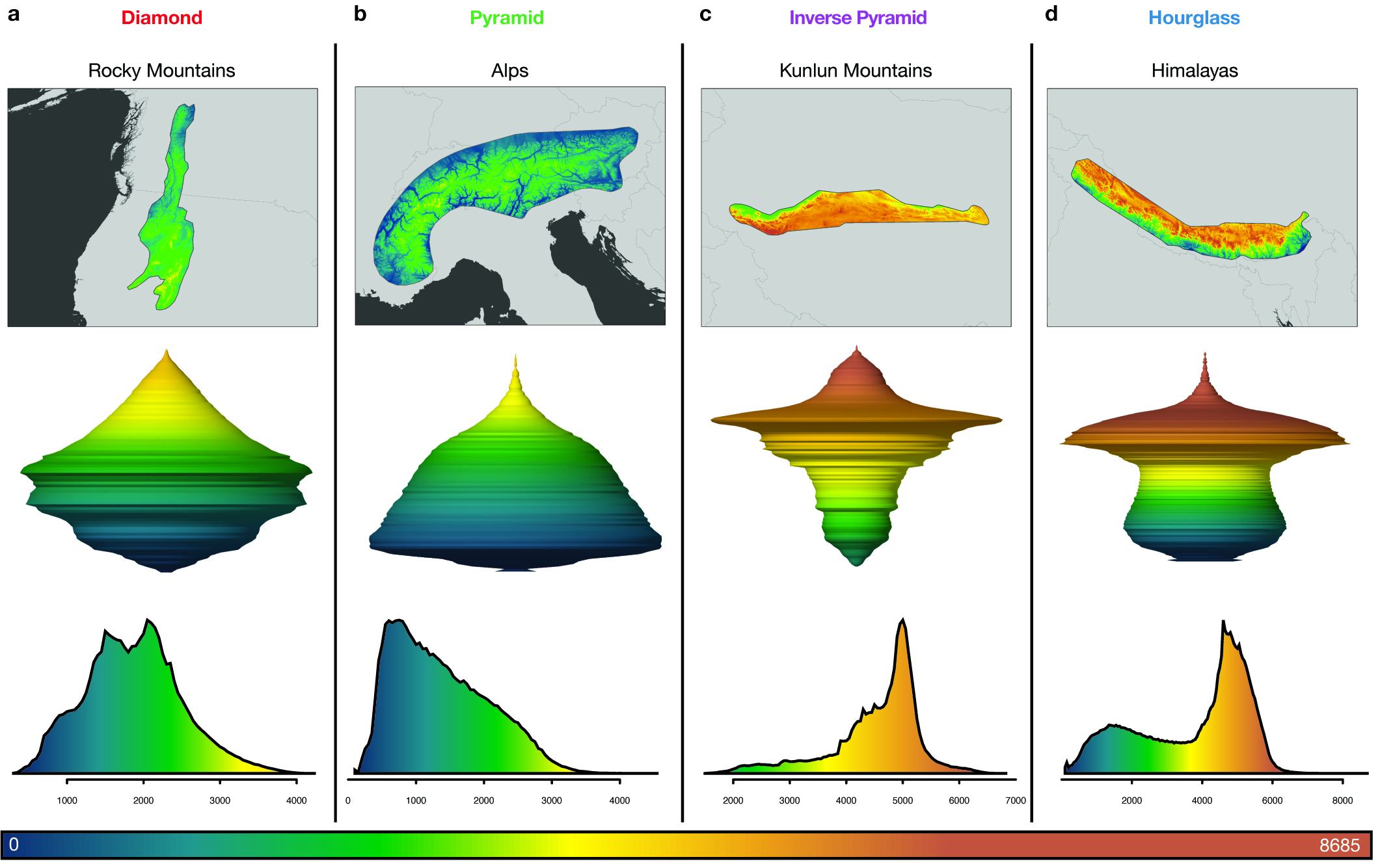
Instead, the 182 mountain ranges the researchers studied take on four principal shapes: diamond, pyramid, inverted pyramid and hourglass. The researchers analyzed high-resolution topography maps for every mountain range to determine land area by elevation. They found that for all the range shapes except pyramid, land availability can be greater at higher elevations than it is farther down the mountainside.

The researchers found that the 182 mountain ranges they studied have four principal shapes. Diamond-shaped ranges such as the Rocky Mountains (a) increase in land area from the bottom until mid-elevation before contracting quickly. Pyramid-shaped mountains such as the Alps (b) have sides that rise sharply and consistently decrease in area the higher they go. The Kunlun Mountains (c) of China take the form of inverse pyramids, which gradually expand in area as elevation increases before suddenly widening toward their peaks. For hourglass-shaped mountain ranges such as the Himalayas (d), land area rises slightly then decreases at mid-elevations before increasing sharply at higher elevations. The three-dimensional images (second row) represent each range shape as viewed from the side. Moving from bottom to top, the width of the shape changes to represent an increase or decrease in area at a specific elevation. Elevation spans from zero to more than 8,685 meters (28,494 feet), and is denoted by the color scale from blue (lowest elevation) to brown (highest elevation). (Image by Paul Elsen, Princeton University Department of Ecology and Evolutionary Biology; Morgan Tingley, University of Connecticut; and Mike Costelloe)

Yet, people’s idea that land area steadily shrinks as a mountain rises is so entrenched that it has come to guide conservation plans and research related to climate change, said first author Paul Elsen, a Princeton graduate student of ecology and evolutionary biology. Scientists project that as mountain species move to higher elevations to escape rising global temperatures they will face a consistent loss of territory — as well as an increase in resource competition — that all but ensures their eventual extinction.

While this risk exists in pyramid-shaped ranges, many species in other range types might in fact benefit from seeking higher altitudes if they move to an elevation with more land area than the one they left, Elsen said. The researchers’ results could be used to more precisely identify those elevation zones where species will encounter territory losses and potentially become more threatened as they move upward, he said. The limited resources that exist for conservation could then be targeted to those species.

“This work should completely change the way we see mountains,” Elsen said. “No one has looked at the shapes of mountain ranges across the entire globe, and I don’t think anyone would expect that only 30 percent of the ranges in the world have this pyramid shape that we have assumed is the dominant shape of mountains.

“That has been the prevailing image of mountains in the public perception and the scientific perception, and it’s really had a big influence on how scientists think mountain species will respond to climate change,” he said.

This slideshow requires JavaScript.

The researchers are the first to measure available area by elevation — known as the hypsographic curve — at the scale at which animals actually live, said co-author Morgan Tingley, a University of Connecticut assistant professor of ecology and evolutionary biology and a past postdoctoral research associate in the Program in Science, Technology and Environmental Policy in Princeton’s Woodrow Wilson School of Public and International Affairs.

“People have explored the global pattern wherein you take all the surface area on the Earth and look at availability versus elevation. If you do that, then you do get a nice pyramidal pattern for all mountain ranges because there are so many low-elevation non-mountainous parts of the world,” Tingley said.

“But that’s not a relevant scale for species or conservation. There is no globally distributed mountain species,” he said. “At the spatial scales at which species live, the majority of mountain regions are not pyramids.”

Map
The researchers examined ranges on every continent except Antarctica and found that the pyramid form in which land-area uniformly decreases as elevation increases only applies to roughly one-third of the world’s mountain ranges. A majority, or 39 percent, of the ranges they studied are diamond-shaped (red), whereas pyramid-shaped mountains (green) constitute only 32 percent. The hourglass shape (blue) characterizes 23 percent of ranges, and only 6 percent of ranges take the form of an inverse pyramid (purple).(Image by Paul Elsen, Princeton University Department of Ecology and Evolutionary Biology, and Morgan Tingley, University of Connecticut)

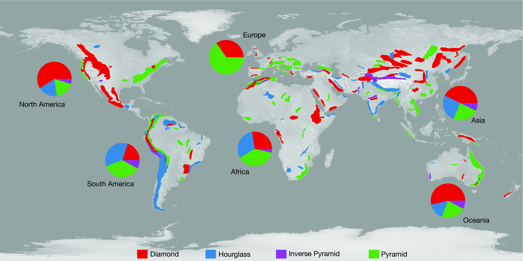
Elsen and Tingley examined ranges on every continent except Antarctica spanning altitudes from zero to more than 8,500 meters (27,887 feet), which is the approximate maximum height of the Himalayas. A majority of the ranges they studied (39 percent) such as the Rocky Mountains are diamond-shaped, meaning that land-area increases from the bottom until the mid-elevation range before contracting quickly.

Hourglass-shaped mountain ranges such as the Himalayas make up 23 percent of ranges. Land area in these types rises slightly then decreases at mid-elevations before increasing sharply at higher elevations.

The nearby Kunlun Mountains of China are representative of the 6 percent of ranges worldwide that take the form of inverse pyramids, which gradually expand in area as elevation increases before, like the hourglass ranges, suddenly widening toward their peaks.

A mainstay of the human mind, pyramid-shaped mountains such as the Alps constitute only 32 percent of the mountain ranges that Elsen and Tingley studied. These mountains have sides that rise sharply and consistently decrease in area the higher they go.

On the other hand, the other range shapes are formed by a series of slopes that rise to open, wide plateaus situated at the base of yet more slopes, Elsen said. These mountains are akin to scaling a giant table where a leg represents a steep, limited-area climb that leads to a high-altitude expanse, he said.

“We expected some interesting exceptions to the pyramid shape – it turned out that pyramids are by far the exception. It’s something that twists your mind around,” Elsen said. “I really encourage people trying to grasp this for the first time to take less of a two-dimensional perspective of looking from the side and picture the range from above — a mountain range is a very three-dimensional system.”

The researchers point out that animals that could benefit from an increase in elevation may still face other threats — habitat loss, food availability and exposure to existing animals and diseases, for instance. Even the range shapes themselves provide unique areas of concern — hourglass-shaped ranges such as the Himalayas, for instance, present a “bottleneck” at mid-elevation that could become overwhelmed with species moving upslope from more expansive lower elevations.

“Not every elevation holds equal value for conservation,” Tingley said. Our research suggests that some gradients, and some portions of gradients, will be more important than others. Protecting land within an elevational bottleneck, for example, will be critical. That is where species will be greatly pressured, and often long before they reach the mountaintop.”

Read the abstract.

Paul R. Elsen and Morgan W. Tingley. 2015. Global mountain topography and the fate of montane species under climate change. Nature Climate Change. Article published online May 18, 2015. DOI: 10.1038/nclimate2656.

The work was supported by Princeton University, the National Science Foundation Graduate Research Fellowship Program (grant no. DGE-1148900), and the D.H. Smith Conservation Research Fellowship administered by the Society for Conservation Biology and financially supported by the Cedar Tree Foundation.

Model anticipates ecological impacts of human responses to climate (Conservation Biology)

A Princeton University research team has created a readily transferable method for conservation planners trying to anticipate how agriculture will be affected by such adaptations. The tested their model by studying wheat and maize production in South Africa. (Image source: WWS)

By B. Rose Huber, Woodrow Wilson School of Public and International Affairs

Throughout history, humans have responded to climate.

Take, for example, the Mayans, who, throughout the eighth and 10th centuries, were forced to move away from their major ceremonial centers after a series of multi-year droughts, bringing about agricultural expansion in Mesoamerica, and a clearing of forests. Much later, in the late 20th century, frequent droughts caused the people of Burkina Faso in West Africa to migrate from the dry north to the wetter south where they have transformed forests to croplands and cut the nation’s area of natural vegetation in half.

Such land transformations, while necessary to ensure future crop productivity, can themselves have large ecological impacts, but few studies have examined their effects. To that end, a Princeton University research team has created a model to evaluate how a human response to climate change may alter the agricultural utility of land. The study, featured in Conservation Biology, provides a readily transferable method for conservation planners trying to anticipate how agriculture will be affected by such adaptations.

“Humans can transform an ecosystem much more rapidly and completely than it can be altered by shifting temperature and precipitation patterns,” said Lyndon Estes, lead author and associate research scholar in the Woodrow Wilson School of International and Public Affairs. “This model provides an initial approach for understanding how agricultural land-use might shift under climate change, and therefore which currently natural areas might be converted to farming.”

Under the direction of faculty members Michael Oppenheimer and David Wilcove, both from the Wilson School’s Program in Science, Technology and Policy, and with the help of visiting student research collaborator Lydie-Line Paroz from ETH Zurich and colleagues from several other institutions, Estes studied South Africa, an area projected to be vulnerable to climate change where wheat and maize are the dominant crops.

Before determining how climate change could impact the crops, the team first needed to determine which areas have been or might be farmed for maize and wheat. They created a land-use model based on an area’s potential crop output and simulated how much of each crop was grown from 1979 to 1999 – the two decades for which historical weather data was available. They also calculated the ruggedness of each area of land, which is related to the cost of farming it. Taking all factors into account, the model provides an estimate of whether the land is likely to be profitable or unprofitable for farming.

To investigate any climate-change impacts, the team then examined the production of wheat and maize under 36 different climate-response scenarios. Many possible future climates were taken into account as well as how the crops might respond to rising levels of carbon dioxide. Based on their land-use model, the researchers calculated how the climate-induced productivity changes alter a land’s agricultural utility. In their analysis, they included only conservation lands – current nature reserves and those that South African conservation officials plan to acquire – that contained land suitable for growing one of the two crops either currently or in the future. However, Estes said the model could be adapted to assess whether land under other types of uses (besides conservation) are likely to be profitable or unprofitable for future farming.

They found that most conservation lands currently have low agricultural utility because of their rugged terrain, which makes them difficult to farm, and that they are likely to stay that way under future climate-change scenarios. The researchers did pinpoint several areas that could become more valuable for farming in the future, putting them at greater risk of conversion. However, some areas were predicted to decrease value for farming, which could make them easier to protect and conserve.

“While studying the direct response of species to climatic shifts is important, it’s only one piece of a complicated puzzle. A big part of that puzzle relates to how humans will react, and history suggests you don’t need much to trigger a change in the way land is used that has a fairly long-lasting impact. ” said Estes. “We hope that conservation planners can use this approach to start thinking about human climate change adaptation and how it will affect areas needing protection.”

Other researchers involved in the study include: Lydie-Line Paroz, Swiss Federal Institute of Technology; Bethany A. Bradley, University of Massachusetts; Jonathan Green, STEP; David G. Hole, Conservation International; Stephen Holness, Centre for African Conservation Ecology; and Guy Ziv, University of Leeds.

The work was funded by the Princeton Environmental Institute‘s Grand Challenges Program.

Read the abstract.

Estes LD, Paroz LL, Bradley BA, Green JM, Hole DG, Holness S, Ziv G, Oppenheimer MG, Wilcove DS. Using Changes in Agricultural Utility to Quantify Future Climate-Induced Risk to Conservation Conservation Biology (2013). First published online Dec. 26, 2013.