Asian ozone pollution in Hawaii is tied to climate variability (Nature Geoscience)

Asian air pollution
Asian pollution drifts east toward North America in 2010. Hawaii is denoted by the star. (Source: Nature Geoscience)

By Joanne Curcio, Program in Atmospheric and Oceanic Sciences

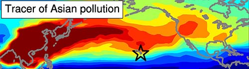
Air pollution from Asia has been rising for several decades but Hawaii had seemed to escape the ozone pollution that drifts east with the springtime winds. Now a team of researchers has found that shifts in atmospheric circulation explain the trends in Hawaiian ozone pollution.

Ozone levels during autumn 1975-2012
Researchers found that ozone levels measured during autumn at Mauna Loa Observatory in Hawaii (black line) accurately reflect the trend in rising Asian air pollution from 1975 to 2012. The researchers demonstrated that the autumnal rise in ozone could be explained by atmospheric and climatic shifts over periods of decades. Using a chemistry-climate model, the researchers modeled this autumnal variation in ozone using constant (red) and time-varying (purple) emissions of ozone precursors. (Source: Nature Geoscience.)

The researchers found that since the mid-1990s, these shifts in atmospheric circulation have caused Asian ozone pollution reaching Hawaii to be relatively low in spring but rise significantly in autumn. The study, led by Meiyun Lin, an associate research scholar in the Program in Atmospheric and Oceanic Sciences (NOAA) at Princeton University and a scientist at the National Oceanic and Atmospheric Administration’s Geophysical Fluid Dynamics Laboratory, was published in Nature Geoscience.

“The findings indicate that decade-long variability in climate must be taken into account when attributing U.S. surface ozone trends to rising Asian emissions,” Lin said. She conducted the research with Larry Horowitz and Songmiao Fan of GFDL, Samuel Oltmans of the University of Colorado and the NOAA Earth System Research Laboratory in Boulder; and Arlene Fiore of the Lamont-Doherty Earth Observatory at Columbia University.

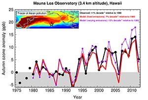
Although protective at high altitudes, ozone near the Earth’s surface is a greenhouse gas and a health-damaging air pollutant. The longest record of ozone measurements in the U.S. dates back to 1974 in Hawaii. Over the past few decades, emissions of ozone precursors in Asia has tripled, yet the 40-year Hawaiian record revealed little change in ozone levels during spring, but a surprising rise in autumn.

Through their research, Lin and her colleagues solved the puzzle. “We found that changing wind patterns ‘hide’ the increase in Asian pollution reaching Hawaii in the spring, but amplify the change in the autumn,” Lin said.

Using chemistry-climate models and observations, Lin and her colleagues uncovered the different mechanisms driving spring versus autumn changes in atmospheric circulation patterns. The findings indicate that the flow of ozone-rich air from Eurasia towards Hawaii during spring weakened in the 2000s as a result of La-Niña-like decadal cooling in the equatorial Pacific Ocean. The stronger transport of Asian pollution to Hawaii during autumn since the mid-1990s corresponds to a positive pattern of atmospheric circulation variability known as the Pacific-North American pattern.

“This study not only solves the mystery of Hawaiian ozone changes since 1974, but it also has broad implications for interpreting trends in surface ozone levels globally,” Lin said. “Characterizing shifts in atmospheric circulation is of paramount importance for understanding the response of surface ozone levels to a changing climate and evolving global emissions of ozone precursors,” she said.

The work was supported by NOAA’s Cooperative Institute for Climate Science at Princeton University. Ozone measurements were obtained at Mauna Loa Observatory, operated by NOAA’s Earth System Research Laboratory.

Read the abstract

Meiyun Lin, Larry W. Horowitz, Samuel J. Oltmans, Arlene M. Fiore, Songmiao Fan. Tropospheric ozone trends at Mauna Loa Observatory tied to decadal climate variability. Nature Geoscience, Published Online: 26 January, 2014, http://dx.doi.org/10.1038/ngeo2066.

Model anticipates ecological impacts of human responses to climate (Conservation Biology)

A Princeton University research team has created a readily transferable method for conservation planners trying to anticipate how agriculture will be affected by such adaptations. The tested their model by studying wheat and maize production in South Africa. (Image source: WWS)

By B. Rose Huber, Woodrow Wilson School of Public and International Affairs

Throughout history, humans have responded to climate.

Take, for example, the Mayans, who, throughout the eighth and 10th centuries, were forced to move away from their major ceremonial centers after a series of multi-year droughts, bringing about agricultural expansion in Mesoamerica, and a clearing of forests. Much later, in the late 20th century, frequent droughts caused the people of Burkina Faso in West Africa to migrate from the dry north to the wetter south where they have transformed forests to croplands and cut the nation’s area of natural vegetation in half.

Such land transformations, while necessary to ensure future crop productivity, can themselves have large ecological impacts, but few studies have examined their effects. To that end, a Princeton University research team has created a model to evaluate how a human response to climate change may alter the agricultural utility of land. The study, featured in Conservation Biology, provides a readily transferable method for conservation planners trying to anticipate how agriculture will be affected by such adaptations.

“Humans can transform an ecosystem much more rapidly and completely than it can be altered by shifting temperature and precipitation patterns,” said Lyndon Estes, lead author and associate research scholar in the Woodrow Wilson School of International and Public Affairs. “This model provides an initial approach for understanding how agricultural land-use might shift under climate change, and therefore which currently natural areas might be converted to farming.”

Under the direction of faculty members Michael Oppenheimer and David Wilcove, both from the Wilson School’s Program in Science, Technology and Policy, and with the help of visiting student research collaborator Lydie-Line Paroz from ETH Zurich and colleagues from several other institutions, Estes studied South Africa, an area projected to be vulnerable to climate change where wheat and maize are the dominant crops.

Before determining how climate change could impact the crops, the team first needed to determine which areas have been or might be farmed for maize and wheat. They created a land-use model based on an area’s potential crop output and simulated how much of each crop was grown from 1979 to 1999 – the two decades for which historical weather data was available. They also calculated the ruggedness of each area of land, which is related to the cost of farming it. Taking all factors into account, the model provides an estimate of whether the land is likely to be profitable or unprofitable for farming.

To investigate any climate-change impacts, the team then examined the production of wheat and maize under 36 different climate-response scenarios. Many possible future climates were taken into account as well as how the crops might respond to rising levels of carbon dioxide. Based on their land-use model, the researchers calculated how the climate-induced productivity changes alter a land’s agricultural utility. In their analysis, they included only conservation lands – current nature reserves and those that South African conservation officials plan to acquire – that contained land suitable for growing one of the two crops either currently or in the future. However, Estes said the model could be adapted to assess whether land under other types of uses (besides conservation) are likely to be profitable or unprofitable for future farming.

They found that most conservation lands currently have low agricultural utility because of their rugged terrain, which makes them difficult to farm, and that they are likely to stay that way under future climate-change scenarios. The researchers did pinpoint several areas that could become more valuable for farming in the future, putting them at greater risk of conversion. However, some areas were predicted to decrease value for farming, which could make them easier to protect and conserve.

“While studying the direct response of species to climatic shifts is important, it’s only one piece of a complicated puzzle. A big part of that puzzle relates to how humans will react, and history suggests you don’t need much to trigger a change in the way land is used that has a fairly long-lasting impact. ” said Estes. “We hope that conservation planners can use this approach to start thinking about human climate change adaptation and how it will affect areas needing protection.”

Other researchers involved in the study include: Lydie-Line Paroz, Swiss Federal Institute of Technology; Bethany A. Bradley, University of Massachusetts; Jonathan Green, STEP; David G. Hole, Conservation International; Stephen Holness, Centre for African Conservation Ecology; and Guy Ziv, University of Leeds.

The work was funded by the Princeton Environmental Institute‘s Grand Challenges Program.

Read the abstract.

Estes LD, Paroz LL, Bradley BA, Green JM, Hole DG, Holness S, Ziv G, Oppenheimer MG, Wilcove DS. Using Changes in Agricultural Utility to Quantify Future Climate-Induced Risk to Conservation Conservation Biology (2013). First published online Dec. 26, 2013.